


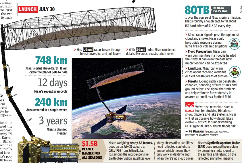
Built By Isro & Nasa, This Satellite Could Become Our Planet’s Early Warning System For Floods, Crop Loss, Coastal ErosionOur planet is constantly changing. The ground shifts, often unnoticed. Glaciers inch forward, coastlines retreat and forests thin or thicken with the seasons. Some of these changes unfold slowly. Others strike without warning.On Wednesday, July 30, a satellite called Nisar (Nasa-Isro Synthetic Aperture Radar), the first joint satellite mission for the two space agencies, will lift off to track these movements. It will scan the Earth’s surface every 12 days, capturing changes as small as a few centimetres. Each pixel will represent an area roughly half the size of a tennis court.The data Nisar will gather will serve a variety of purposes — it will warn of flooding, coastline erosion, guide realtime disaster response, improve food security and even track ships. It will be one of the most advanced Earth-observation satellites ever to go up.
Beaming to villagesNisar’s launch also comes 50 years after India and US collaborated on a very different kind of project: the Satellite Instructional Television Experiment, or SITE.Launched a month after then PM Indira Gandhi declared the Emergency, SITE began broadcasting on Aug 1, 1975 to community TV sets in 2,400 villages across Karnataka, Rajasthan, Odisha, Bihar, Madhya Pradesh and Andhra Pradesh. It was seen as a mutually beneficial deal for Nasa and Isro.At the time, 40% of India’s population was in villages with fewer than 3,000 people, and a quarter were in hamlets with fewer than 200. Traditional infrastructure alone couldn’t reach them, but space tech could. So, an agreement was made: The US would supply its ATS-6 telecommunications satellite for a test run; India would build the ground infrastructure.
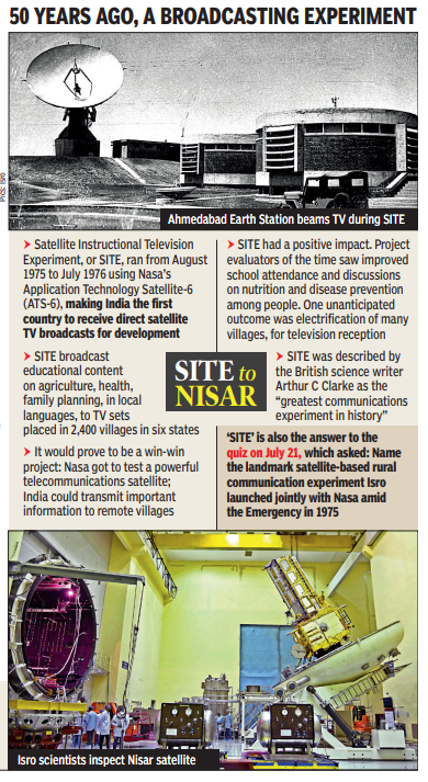
The experiment was a success. SITE reached around 2 lakh people, helped train 50,000 science teachers in primary schools and beamed advice to thousands of farmers, becoming “the largest sociological experiment in the world”.Before SITE, India and US had worked together in space for close to a decade, but this was the first time their efforts touched lives.50 years apart“It took 50 years from one major joint project in communications and broadcasting to another project on Earth observation,” former Isro deputy director Arup Dasgupta, who led deployment of SITE’s receivers, told TOI.He said Nisar’s launch showed how much Isro had progressed. “Fifty years ago, we used a Nasa satellite to beam educational programmes. Today, we are launching their payload along with our own Synthetic Aperture Radar on an Indian launcher.”Nisar has been described by Nasa-JPL project scientist Paul Rosen as “a storyteller of Earth’s changing surface”. The satellite will capture motion of land, ice, water and vegetation across seasons, which means data for seismologists, climatologists, agriculturists, conservationists and many others. And the information will be freely available to them.A dual-band instrumentEquipped with dual radar systems — the L-band by Nasa and Sband by Isro — Nisar can see through clouds and observe Earth day or night. It will scan the Himalayas, beaches of California, the Amazon rainforest and the farms of Punjab — not just once, but repeatedly, creating a time series of surface changes that show what has shifted, where and how fast.“It lets us read Earth’s surface like a series of moving frames,” Rosen said. “Using SAR, we can measure ground displacement down to even millimetre precision.”The longer-wavelength L-band penetrates vegetation and interacts with features such as rocks and tree trunks. Shorter S-band captures surface details like leaves and topsoil. Combined, they allow scientists to view the same landscape through two different lenses, revealing structure and change.“A dual-band SAR like this has never flown before. L-band opens up deeper imaging and new interferometric applications. You can track deformation, subsidence, and seismic shifts in much finer detail,” said professor PG Diwakar of the National Institute of Advanced Studies.One major focus will be the Himalayas. “We’ve never had such a tool for studying Himalayan snow, glaciers and lake systems. Nisar will let us observe how glacial lakes evolve — critical for understanding GLOF (glacial lake outburst flood) risk,” Diwakar said. L-band’s ability to see below the canopy also improves forest assessments. For farmers, it will help forecast yields and assess crop loss.In disaster-prone areas, Nisar’s interferometric accuracy will boost early detection, measuring ground shifts over wide regions. It will even aid during oil spills. “This will be the first mission between US and India to observe Earth in such a detailed way,” said Nicola Fox, associate administrator, Nasa science mission directorate.Roots in 1978Nisar’s roots go back to a breakthrough launch in 1978, when Nasa put in orbit Seasat — the world’s first satellite with SAR. The mission lasted only 105 days, but the data this satellite produced reshaped Earth observation. Now, nearly 50 years after Seasat, Nisar is set to go up and stay there for at least three years, generating more data daily than any other previous remote-sensing satellite.For India, which will handle its launch, the satellite deepens its scientific engagement with the world. For Nasa, it extends an Earth observation legacy.Together, they have created something greater than the sum of their parts — a satellite that watches Earth not as a snapshot, but as a breathing, evolving whole.


