


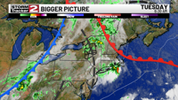
Scattered showers and thunderstorms continue today across Central New York. Highs Tuesday in the low 80s with tropical levels of humidity, dew points into the low 70s.
A cold front begins to approach from the west, and this will spark thunderstorms for the afternoon and early evening. Thunderstorms look possible 12-6pm, a few may be on the stronger side. The primary threat is yet again straight-line winds and heavy rain; the greatest threat is for areas to the east and south of Utica. Conditions calm down and dry out during the second half of Tuesday evening, and calm weather settles in for Wednesday.
We finally get more refreshing air on Wednesday as the humidity drops, partly sunny skies with highs in the low 80s, a pleasant day. Another cold front brings more scattered thunderstorms on Thursday with highs in the upper 70s. Fantastic weather in the forecast for Independence Day, mostly sunny skies with highs in the mid to upper 70s. This continues into the first half of the weekend, where Saturday is partly sunny with highs back into the low 80s. The chance for thundershowers returns for Sunday and Monday with highs in the mid 80s.


