


BBC Verify

 BBC
BBCIsraeli strikes have damaged structures at two missile sites as well as an airport runway, satellite images have revealed.
As Iran and Israel continue to launch strikes on each other’s territory, satellite imagery can give us an insight into what’s happening on the ground.
It’s a particularly valuable resource when looking at Iran – where it’s very difficult for BBC journalists to operate.
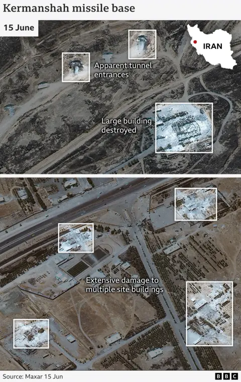
The latest satellite imagery released by Maxar shows damage to a missile base operated by Iran’s Islamic Revolutionary Guard Corps (IRGC) near the western province of Kermanshah.
High-resolution images taken on 15 June show multiple buildings targeted at the facility. A number of structures appear to be completely destroyed, with debris spread out around the site.
There is also damage to what appear to be two tunnel entrances up against the mountainside, likely used to store sensitive equipment away from attacks.
Iran’s ballistic missiles are known to be buried deep in underground silos spread out across the country.
Jeremy Binnie, Middle East specialist at Janes defence intelligence, says in addition to the targeting of missile storage bunkers and launchers, “the buildings targeted could include barracks”, which would suggest “an attempt to reduce the number of personnel able to man missile launchers for retaliatory attacks”.
“Kermanshah is one of Iran’s oldest ballistic missile bases,” says Fabian Hinz, a military analyst at the International Institute for Strategic Studies (IISS), “having originally been established during the Iran-Iraq war in the 1980s. More recently, it has played a key role in various Iranian missile strikes including against various armed groups and Israel.”
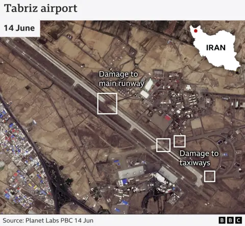
Satellite images from Planet Labs show several areas of significant damage at the international airport in Tabriz, capital of Iran’s East Azerbaijan province.
Images taken on 14 June show a large blackened area clearly visible in the centre of the main runway. There are also signs of damage to two taxiways at two points where they meet the main runway and on another section of one of the taxiways.
It’s not clear if the airport is currently operational, but the Flightradar24 tracking website shows no commercial flights arriving or departing since early on Friday, when Israel first launched attacks on Iran.
Flight tracking sites would not normally register the movement of military aircraft.
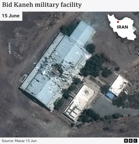
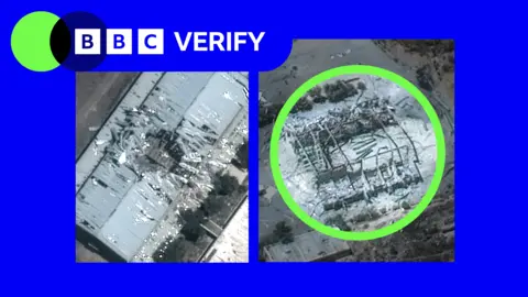
This site, about 30km (19 miles) west of Tehran, has apparently sustained damage to multiple buildings. In a Maxar image from 15 June, you can see a roof of a large structure has been penetrated and there appears to be further damage to another building alongside.
This isn’t the first time this facility at Bid Kaneh has suffered serious damage. In 2011 a large explosion is reported to have killed a number of personnel believed to have been working on Iran’s missile programme.
At the time, the Iranian authorities blamed it on an accident, although there was also speculation it was an act of sabotage.
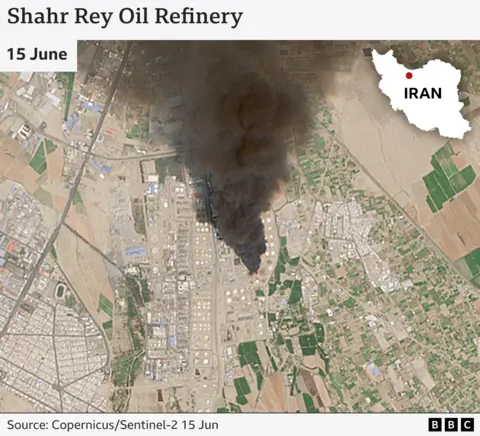
Images from the EU’s Sentinel-2 satellites from 15 June show large plumes of smoke coming from two energy facilities in the Iranian capital, Tehran.
Shahr Rey is reported to be one of the largest refineries in the country, capable of refining 225,000 barrels per day.
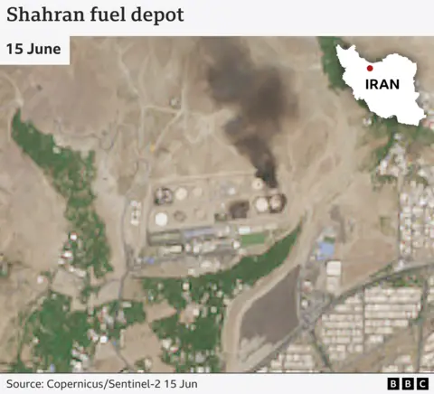
The second site, Shahran oil and gas depot, is a key hub for distributing fuel in the north of the capital. There are signs of damage to several structures on the site.
Iranian officials have acknowledged the strikes, but played down their significance.
Shana, the oil ministry’s news agency, reported that the situation was “under control”, that the containers at Shahran were not full when struck, and that the refinery was still operational.
We will update this piece as more satellite imagery and analysis becomes available.
Additional reporting by Kayleen Devlin & Ned Davies


